What is a Plat of Survey
A Plat of Survey refers to a legally approved map that delineates the different boundaries and dimensions between properties, neighbors and elements on an area of land that is owned by an individual or company. It usually involves a large area of land, using the distances and directions of this property and elements on the lot or parcel. A licensed surveyor must complete and stamp your Plat of Survey. Plat of Survey is required to began any architectural project. It is the starting point to show that you are engaging professionals and moving forward on your project.
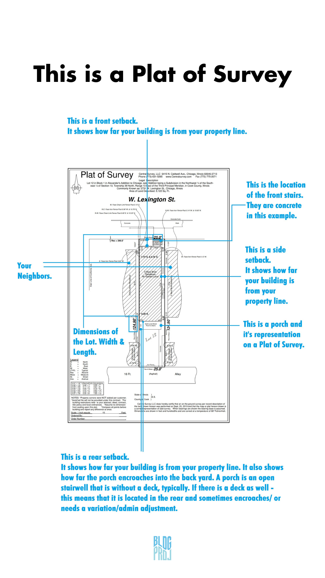
The contents of a plat of survey
A Plat of Survey generally contains the visual representation and the legal description of the land and property/elements located on it., I.E. a property is a building located on a land area. To properly show the visual representation in 2d drawn format, the large area of land will be measured on site with tools and legal description as a base, using distances and boundaries to describe the elements and landmarks on the property. Elements can be Enclosed Wood Porches, Garages, Decks, Patios, Landscaping, Asphalt, Concrete, Driveway, Pools, Lightwells etc. that are elements drawn on your survey in conjunction with your building.
You can use it to determine the proper position of the corner piece, fence line, drill holes, etc. It contains proposed improvements on the land. It also includes a legal description of the land.
The use of a plat of survey
Because of its vivid representation, a Plat of Survey clearly shows the length and breadth of properties and elements on the land. It also aids the proper designation of public facilities such as driveways. It also ensures compliance with government regulations and policies on buildings. It is the starting project document for Architects to determine the required setbacks and allowed areas on your lot.
The types of the plat of survey
Boundary Survey: This is used for general interior/exterior improvements. A Boundary Survey is recommended before buying, subdividing, improving or building on land. The purpose of a Boundary Survey is to map and identify the location of property lines. The surveyor looks for any easements, encroachments, surrounding property and past documented records. Easements can include utilities such as water, sewer and power lines on the property. Encroachments refer to any person, other than the owner, utilizing the land that isn’t authorized to do so. Examples of an encroachment include: neighboring driveways, fences, structures, etc. that go past the property line. Once the Boundary Survey is completed the surveyor then creates a “Plat of Survey” that documents all pertinent information to that property. A Boundary Survey is commonly completed prior to buying property because it legally protects against future disputes and rebuilding.
ALTA Survey: An ALTA Survey conforms to the standards set by the American Land Title Association (ALTA) and the National Society of Professional Surveyors (NSPS) Land Title Survey Specifications. It is a detailed map of the land that shows all existing improvements, utilities, major observations, and any possible areas indicating potential future use within the land. An ALTA Survey is the most extensive survey because it combines information from the Boundary, Title, and Location Surveys. An ALTA Survey’s precise detail makes it beneficial to lenders, corporations, title companies, general public, architects, engineers and contractors. A current title commitment is required prior to conducting an ALTA Survey.
Topographic Survey: A Topographic Survey focuses on the configuration (relief) of the surface of the land and the location of naturally occurring objects and artificial improvements. The purpose of this survey is to identify the terrain and existing features that are below or above the land surface (trees, buildings, utility poles, retaining walls etc.). Topographic Surveys are essential for architects, land owners and developers because they are accurate 3D depictions of the land.
Construction/Staked Survey: This is used for any New Construction Projects. This process lays out calculated survey points for a property in which improvements are to be constructed which serve as a guide in the construction of those improvements as set forth from plans prepared by a design professional, such as an architect. Aspects of this process include surveying the existing land and improvements, setting stakes to represent the lot corners, limits of work areas, construction trailer location, and other markers to guide in the construction of the new structures. A foundation survey is completed to confirm the location of the foundation is correct. Later, an As-Built Survey verifies the work has been completed in accordance with the set of plans.
Subdivision: When a landowner wants to apportion their land into smaller bits, the land measurements must be taken. This is a plat of subdivision.
Consolidation: When a landowner expands their land by joining it with adjoining lands, the measurements of the lands must be taken. This is known as plats of consolidation. It is joining multiple parcels of land for 1 project or scope of work. Typically, this is done to make a larger building.
ISSUES WITHOUT HAVING A plat of survey
You cannot accurately begin your project, because you do not know where your land starts and ends.
Your architect cannot make informed decisions and suggestions for your project.
Specifically in certain states and cities, such as Chicago - the location of your buildings wall to your property line dictates where your livable areas [bedrooms, living room, dens, offices] can be. If you do not have 36” min. to your property line from the side of the building, you are NOT allowed to use this side for required light and ventilation.
DID YOU KNOW?
A typical Chicago lot is 25 FT. wide by 125 Ft. long
Irregular sized lots are less than 25 FT. wide and those are problematic for building a standard size building. Usually these lots require more attention to detail because of their unique dimension.
You can use a Land Use Attorney to check feasibility if your lot is buildable for your design goals.
You need a Plat of Survey, no older than 6 months at the time of submission to the City of Chicago. This means you should consult with your architect on deadline dates.
You should receive a Plat of Survey at your closing. If you do not, please reach out to your closing attorney.
Your Plat of Survey will show the distances from the rear, front, and sides of your owned lot, to the beginning of your building.
Typical Survey costs are between $350 - $1,150 pending lot size and surveyor. Your architect may be allowed to acquire at a discounted rate.
Having an experienced architecture team on your side is crucial to the building and design process. Contact BLDG Projects Chicago for more information. Call us at 773.784.9755
References: https://www.psisurvey.com/our-products/